Emergency Management & Incident Command

Field situational awareness for every responder
& every incident.

Dispatch needs to know where crews are. Field teams need context to make good decisions. Vector keeps everyone connected — showing locations, assignments, and status in real time, whether you're at the EOC or in the field. No enterprise deployment. No server infrastructure. Operational in minutes.

The Challenge

When incidents scale up,
coordination breaks down.

Field crews working with incomplete information

Responders leave the command center with paper maps and radio frequencies. They don't know where other crews are, what's already been checked, or how the situation is evolving around them.

Dispatch can't see the field

You know what crews are assigned to, but not exactly where they are or what they're finding. Radio check-ins don't scale, and the bigger the incident, the harder it gets to maintain visibility.

Crew accountability takes too long

When you need to verify a crewmember is safe or account for everyone on scene, you're competing for radio time with operational traffic. Personnel tracking shouldn't require a roll call.

Mutual aid creates interoperability headaches

When neighboring counties or state resources show up, they're on different radio systems, different software platforms, and unfamiliar with your area. Getting everyone on a common operating picture takes precious time, if it happens at all.

How Vector Helps

Real-time coordination for dispatch and the field.

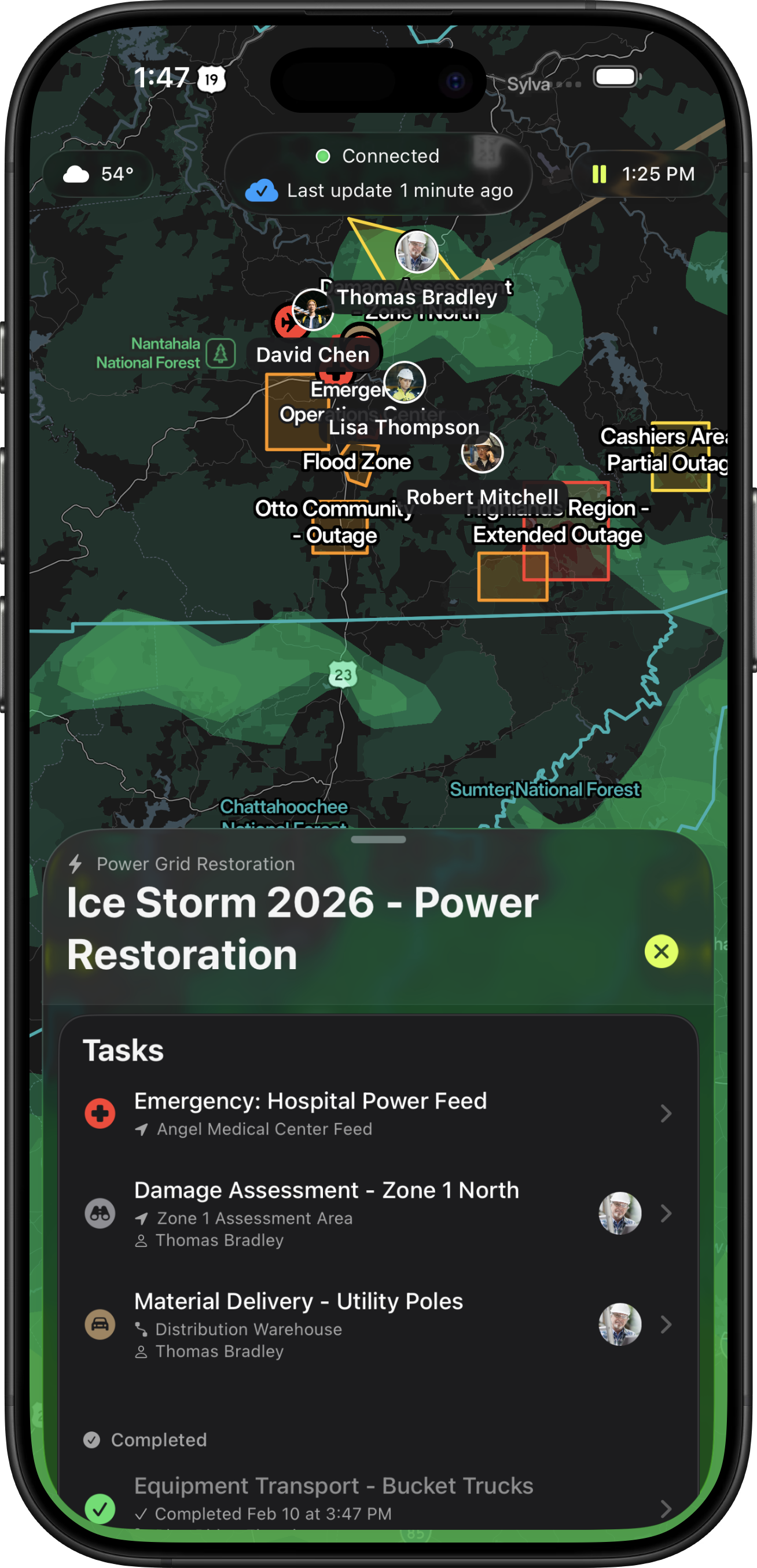
Vector shows crew locations, assignments, and status on everyone's device — whether they're at the EOC using the web interface or on scene with the iOS app. Built to work offline and sync peer-to-peer, so your coordination tools stay up even when cell networks don't.

Location Tracking & Assignment Visibility

See every responder's location and
what they're working on.

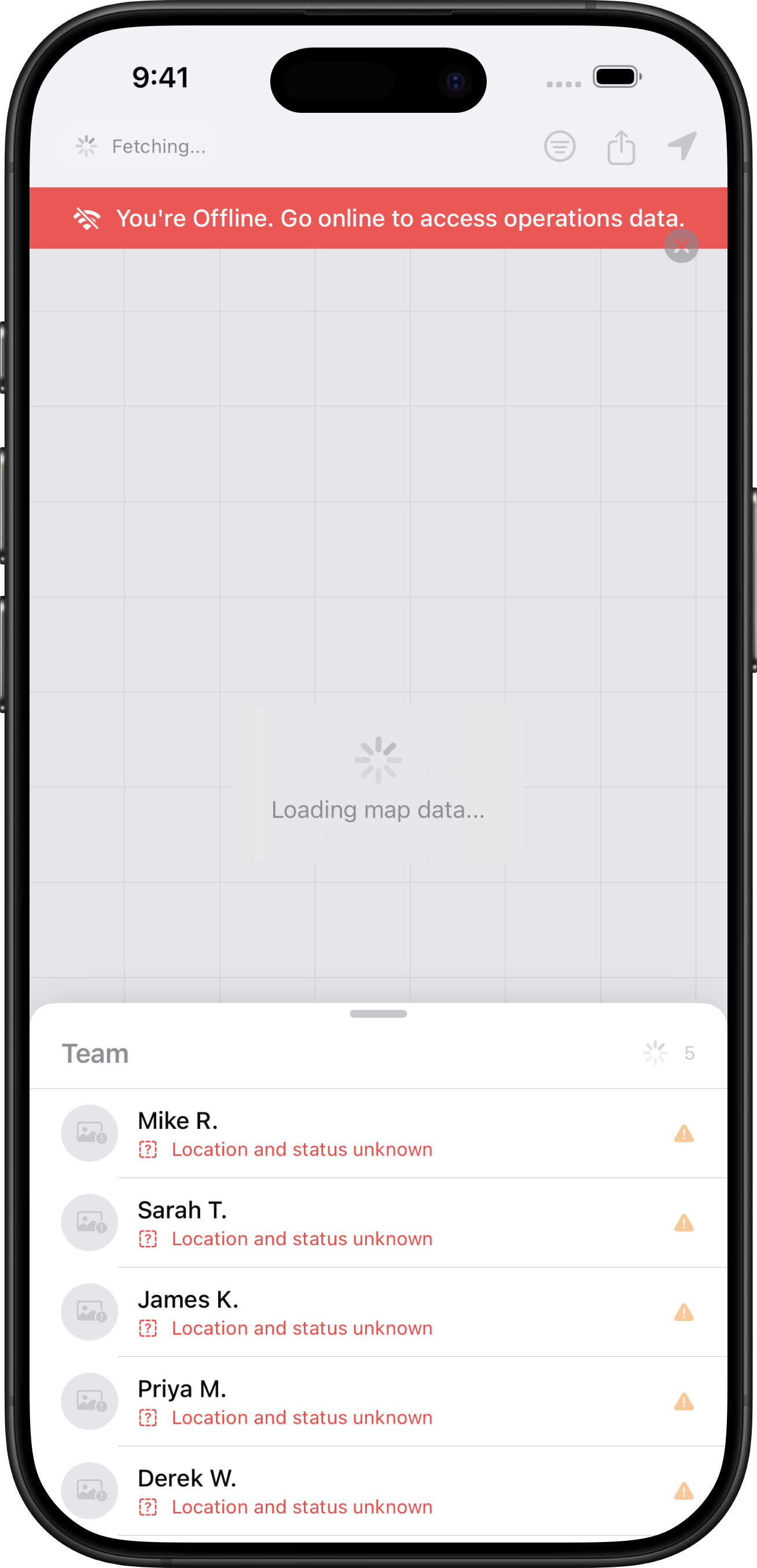
Real-time GPS positioning shows every crewmember's live location and assignment, from the EOC's web dashboard or from the field on iOS. Responders can identify nearby resources, see what's been covered, and coordinate without radio back-and-forth. Accountability data updates automatically across all devices, so when you need to verify a crew is safe or account for everyone on scene, the information is already there. No more tying up the radio or waiting for a manual roll call.

Vector real-time team tracking dashboard showing live GPS positions
Resource Management

Every vehicle, asset, and resource — tracked and assigned.

Register and track vehicles, equipment, and resources across your operations. Drag-and-drop assignment lets you quickly allocate assets to crews and tasks, and when assignments change, status propagates automatically. Whether it's a generator, a mobile command unit, or a fleet of trucks, you always know where it is and who's using it.

Multi-Agency Interoperability

Multi-agency interoperability without the headaches.

When state resources or neighboring counties arrive, they scan a QR code and they're in. No complex accounts, no required training, no manual radio bridging. They see what they need to see, you see where they are, and everyone's working from the same operational picture.

Tactical Coordination

Draw the picture.
Share it instantly.

Define operational regions, safety perimeters, and alert zones directly on the shared map. Tag areas for automatic notifications when personnel enter or exit. View personnel breadcrumbs and historical tracks for post-incident review and accountability. Every annotation syncs to all devices in real time, giving your field teams and the EOC the same tactical picture.

Offline-First Architecture

Built for degraded and offline environments.

Vector syncs device-to-device through peer-to-peer mesh networking, so your coordination doesn't depend on cell coverage, cloud servers, or any centralized infrastructure. When crews move into dead zones or network infrastructure is compromised, they still have the complete picture, and their updates propagate to the rest of the team automatically when any device regains a signal.

Without Vector
With Vector
App showing no connection error
Vector working offline with full functionality
Integrations

Connected to your
CAD and RMS.

Vector integrates with major CAD and RMS systems. When a CAD incident is created, Vector can instantly alert your team and dynamically assign units, getting the right resources moving before crews even reach the radio. Pushing data to your RMS enables seamless integration with NERIS reporting and post-incident documentation.

CAD RMS
Data

Your data, available everywhere — online or off.

Import GIS layers, custom map data, and real-time feeds directly into Vector. Traffic conditions, weather overlays, fire perimeters, infrastructure maps — all available on every device in the field, even offline. Supports GeoJSON, GPX, and custom data sources so your team has the complete picture wherever the mission takes them.

See how Vector works
for emergency management.

Real-time coordination that works
when infrastructure doesn't.

Schedule a Demo Download Now